| And
it shall come to pass, at the end of seventy years, that JEHOVAH
will take note of Tyre (Phoenicia).
She will return to her trading, and commit fornication with
all the kingdoms of the world on
the face of the earth (Isaiah 23:17). |
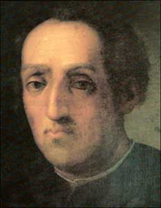
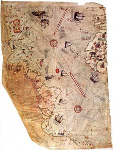
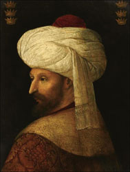
TERRIBLE TURKISH ADMIRAL PIRI REIS
Ancient Tyre was the British Empire (Tyrant) of the ancient world and the Phoenicians had an absolute monopoly on trade with the New World. The Phoenicians were actually Canaanites who were driven out of the Promised Land by the sword of Joshua the son of Nun.
Piri Reis (full name Hajji Ahmed Muhiddin Piri Reis) was a Turkish admiral, geographer, and cartographer, who made detailed maps of the New World that no modern explorers had discovered up to that time. The maps show the precise latitude and longitude of the New World in relation to Africa. Not until the invention of the marine chronometer 200 years later was longitude determined with precision.
|
|
|
|

In 1492, Spanish sovereigns Ferdinand and Isabella conferred on Salvador Fernandez Zarco a.k.a. Christopher Columbus the title "Admiral of the Ocean Sea" and sent him westward to claim the entire New World for Spain. This diabolical conspiracy also involved Spanish Rodrigo Borgia a.k.a. Pope Alexander VI.
In Fourteen Hundred Ninety Two
Columbus sailed the ocean blue.
With maps in hand drawn long before
He headed straight for Cabot's shore.
Much fame he gained, so I am told,
For he proved true the maps of old.
Columbus knew all about the New World because detailed maps were available going back at least 3,000 years. The Phoenicians, with headquarters in Tyre, Lebanon, were a great (and extremely wicked) seafaring people who had colonies all over the world.
The ships of Cabot and Columbus were puny compared to the massive oceangoing vessels of the Phoenicians. These vessels, and the extreme wickedness of the Phoenicians, are described in Ezekiel chapters 26, 27, and 28. In Ezekiel 28:13, the king of Tyre is compared to Lucifer the Devil
The Chinese were also here long before Columbus and there are maps to prove it.
|
|
|
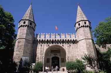
Topkapi Palace Museum. |
The Piri Reis map is currently located in the Library of the Topkapı Palace in Istanbul, Turkey, but unfortunately it is not usually on display to the public. Admiral Piri Reis said that he got the information for his map from a captured Spanish sailor who had accompanied Columbus on his 3 voyages to the New World. The admiral said that some of the information came from maps made by Alexander the Great.
We know that no Spanish sailor had maps of the New World because maps were TOP SECRET at that time and were locked up securely in state archives.
|
|
|
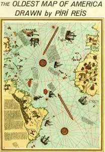
Piri Reis detailed map of the New World. |
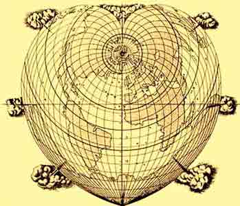
A later map by admiral Piri Reis shows the entire globe with no ice at the North or South Pole, and a huge land bridge between Siberia and Alaska. According to Darwinian evilution, the Ice Age began 2.6 million years ago!!
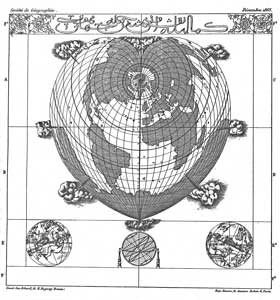
 A globe of the ancient world. |
|
 Hajji Ahmed 1559 globe. |
By 1559, no European nation had the means of correctly determining longitude. This can only be determined by a marine chronometer or by trailing a string or rope behind the vessel to find out how far the ship has traveled:
In some respects this Turkish map of 1559 is one of the most remarkable I have seen. There is a striking difference between the drawing of the eastern and western hemispheres. The eastern hemisphere seems to have been based on the sources available to geographers of the time, mostly Ptolemy, and to be somewhat ordinary. The map of the Mediterranean is still evidently based on Ptolemy instead of on the much better portolan maps. The African coasts do not compare in accuracy with the same coasts on the Piri Reis Map of 1513 or on other maps to be discussed shortly.
But if this is true of the eastern hemisphere, it is an entirely different story in the west, and here it is evident that the cartographer had at his disposal some most extraordinary source maps. The shapes of North and South America have a surprisingly modern look; the western coasts are especially interesting. They seem to be about two centuries ahead of the cartography of the time. Furthermore, they appear to have been drawn on a highly sophisticated spherical projection. The shape of what is now the United States is about perfect.
This remarkable accuracy of the Pacific coasts of the Americas, and the difficulty of imagining how they could have been drawn in the middle of the 16th century, adds significance to another detail of the map: the suggestion of a land bridge connecting Alaska and Siberia. This land bridge actually existed in the so-called Ice Age. The map suggests that the land bridge was a broad one, perhaps a thousand miles across. (Hapgood, Maps of the Ancient Sea Kings, pp. 84-85).
This global map has baffled the Columbus shills so their reaction is too hide or ignore it. According to these experts, the South Sea or Pacific Ocean was discovered by Vasco Núñez de Balboa in September 1513.
Ancient accurate global maps were preserved in Constantinople!!
Ancient man was a genius compared to the puny brains of today. Charles Darwin reversed the natural order with his evolutionary myth of microbes . . . to monkeys . . . to men....Man has been degenerating since his creation about 6000 years ago.
The Phoenicians and other ancient sea-faring people had accurate charts of the entire world and they had scientific and very accurate means of determining longitude.
The knowledge of the existence of the New World was preserved in New Rome from the Muslims and the Latins until the Fourth Crusade in 1204.
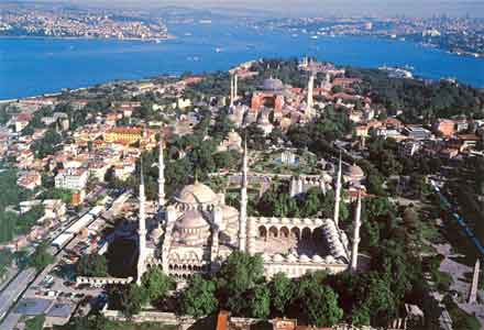
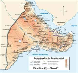 Constantinople was surrounded on 3 sides by water. |
|
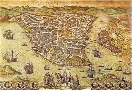 A virtually impregnable city. |
Venice was the premier Mediterranean maritime power of the Middle Ages. In the beginning, Venice always looked to Constantinople as the true headquarters of the Roman Empire; but by 1200 AD times had changed. Venetian ships now aided the Crusaders as they attacked and conquered Constantinople.
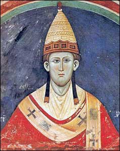 Pope Innocent III (1160–1216). Reigned from 1198 to 1216. |
|
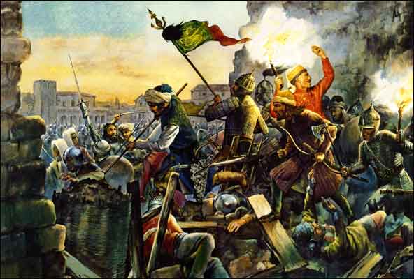
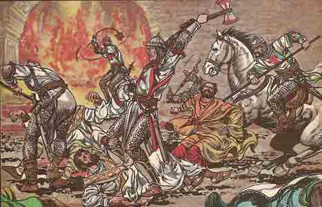 Sack of Constantinople by the Crusaders in 1204. |
The Crusaders were finally driven out of Constantinople in 1261, but by then the knowledge of the existence of the New World had spread to Western Europe. Whether the Crusaders left any maps behind is debatable, but if they had, the Turks would have known of the existence of the New World.
After 1200 AD, many people sailed to the New World. A Welsh group, led by Prince Madoc, sailed to Alabama around 1200 and their descendents were found when the U.S. acquired the Louisiana Territory. They were blue-eyed, white-skinned Indians called Mandans, and very conveniently they were wiped out by smallpox around 1840.
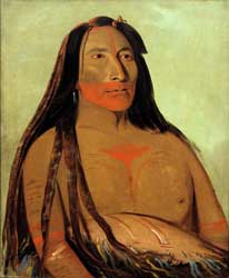 Mandan chief Ma-To-Toh-Pa. |
|
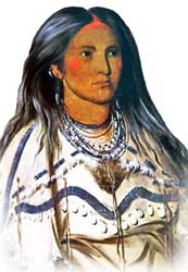 A Mandan women named Nwek-E-Sunk-To-Ca. |
A Scot named Prince Henry Sinclair accompanied the Zeno brothers on their voyage to the New World. Some of the Knights Templar escaped their suppression by emigrating to the New World. Even then, the New World was a refuge for the oppressed people of the world.
1453 was the defining year for the world!!
The Fall of Constantinople was the defining event in the history of the modern world. The Turks gained a stranglehold on the Bosphorus and they began to charge exorbitant prices for the spices and silks from India and China.
Sultan Mehmed II was planning to extend his conquest to Western Europe and this was part of his strategy to bankrupt his enemies.
The spice trade made the Republic of Venice the richest city state in Italy, and the most powerful naval force in the Mediterranean. Before 1453, spices and silk came overland from India and China, and then by Venetian ships to Western Europe. All that ended with the Turkish conquest of the city.
John Cabot arrived in the New World in 1494
Venice was the sailing superpower of the Middle Ages. She was also known as "queen of the seas." Any non-Venetian who wanted to learn oceangoing navigation went to Venice. Maps of the New World stolen from Constantinople existed in Venice, but there is no proof that the Venetians had the knowledge to determine longitude.
The Doge of Venice was now completely committed to breaking the Turkish monopoly, so John Cabot must have seen the New World maps before he left for Bristol, England, in 1480.
|
|
|
|
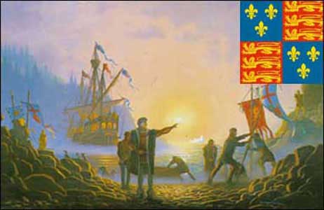
There is an old saying that "you only discover what you are looking for" and Cabot definitely had maps in hand when he sailed from Bristol in 1494. Bristol fishermen were already fishing on the Grand Banks of Newfoundland, and they had no motivation to share their monopoly with any other country. As a Venetian, Cabot was clearly motivated to get to Asia, but he might have looked upon the New World as a barrier to his ambition.
The Terrible Turks and the Venetians were deadly rivals!!
Turkish
naval intelligence was keenly interested in the doings of the Venetians
in the New World. If the Venetians found a shortcut to Asia, this would
break their monopoly on the spice trade.
As a result, admiral Piri Riis stopped and searched every Venetian ship that his navy encountered in the Mediterranean.
It was Venetian ships and Venetian seamanship that stopped the Terrible Turks from conquering all of Europe. The Pope didn't care if the people worshipped Allah or Jupiter as long as he could destroy the blessed Reformation.
 Sultan Selim II (1524 –1574). Sultan from 1566 to 1574. |
|
 The Battle of Lepanto in 1571. |
The Battle of Lepanto, fought on October 7, 1571, was a titanic struggle between the navies of Sultan Selim II and the navies of Venice, Spain, and Genoa. Venice provided most of the ships for the conflict and their brave sailors suffered the heaviest casualties.
By 1513, the Columbus legend had spread widely so admiral Piri Reis mentioned Columbus as the "discoverer" of some islands in the New World. The admiral said that he had obtained the nautical information from a captured Spanish slave who accompanied Columbus on his 3 voyages. All such maps were TOP SECRET and a mere slave would have no access to this information.
Other maps soon emerged that were based on the Columbus legend but were in fact based on maps thousands of years old.
The ancient Egyptians knew all about electricity!!
Darwinian evolution has brainwashed almost everybody into believing that ancient man was a BRUTE who once swung from trees like monkeys....Nothing could be further from the TRUTH.
Noah knew all about electricity because he used floodlighting in the Ark!!
The ancient Egyptians knew that lighting was electricity and they used electricity to light the interior of their pyramids and temples. Some unprejudiced people who have studied ancient technology believe that the pyramids were electric generation stations—pyramid power!!
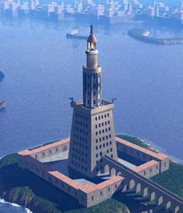
How pathetic it is to see the attempts of evolutionists to explain the illumination of the Pharos Lighthouse—one of the 7 Wonders of the Ancient World. Evolutionists expect us to believe that the Alexandrians carried up wood to the top of the 45-storey tower in order to provide fuel for a fire that could be seen as far away as 32 nautical miles....Egypt had no trees for wood and they certainly didn't have coal mines.
|
|
|
 An artistic conception of the Pharos Lighthouse with electric mirrors–or searchlights. |
The Jewish historian Josephus said that the light was visible from a distance of 300 furlongs. In English nautical miles that would translate as about 32 nautical miles.
All the knowledge of the great inventions of ancient Egypt were DESTROYED when the Muslims invaded Egypt and destroyed the great library in Alexandria.
Benjamin Franklin did not invent the lighting rod....Solomon's Temple in Jerusalem was never damaged by lightning because the entire building was grounded with lightning rods placed at strategic points on the roof of the building.
The great inventor Nikola Tesla rediscovered great principles of electo-magnetism that were well known to the ancient world. The Greeks had a type of death ray powered by electricity that they used successfully against Roman ships. The mysterious Greek Fire has never been duplicated because "scientists" today cannot admit that electricity was widely used in the ancient world.
The modern marine chronometer was not invented until 1760
British Darwinian evolution teaches that ancient man was a brute who once swung from trees like monkeys. The advanced state of ancient geography and cartography proves evolution wrong . . . wrong . . . wrong.
 John Harrison (1693–1776), inventor of the marine chronometer. |
|
 John Harrison's final masterpiece, made around 1760, was a hand held marine chronometer. |
John Harrison–like all great inventors–had to battle years of apathy and ignorance before his invention was accepted by the Royal Navy. We do not know how the ancient Phoenicians navigated, but their maps shows an advanced knowledge of the stationary earth.
Darwinian evolution is a bunch of LIES and should be rejected completely for the true Genesis account of ancient man. Ancient man was far, far smarter and more inventive than modern man. Man has degenerated since Eden and his end will come soon when the Messiah returns and there shall be no more sea:
And I saw a new heaven and a new earth: for the first heaven and the first earth were passed away; and there was no more sea (Revelation 21:1).
Vital Links
References
Deacon, Richard. Madoc & the Discovery of America. George Braziller, New York, 1966.
Hapgood, Charles H, Maps of the Ancient Sea Kings. E.P.Dutton, New York, 1979.
McIntosh, Gregory C. The Piri Reis Map of 1513. University of Georgia Press, Athens, Georgia, 2000.
Copyright © 2015 by Patrick Scrivener